See how this homestead focuses on the nitrogen-cycle to be as self-sufficient as possible!
PLEASE READ THE ENTIRE DESCRIPTION (twice we’ve had people drive around for 5 hours before finding us, because, they didn’t follow the directions. Don’t be that guy.
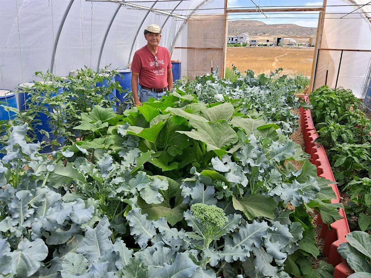
Riverbed Ranch founder, Philip Gleason, will be giving a tour of his 2-acre slice of paradise!
- Guided tour starts at about 11am.
- Bring a water bottle & sack lunch (and snacks, if you’re bringing children).
- Drinking water, restroom and limited cell service (VOIP) available.
- Plan for 2 hours each way if coming from Utah County*.
- Unless you have all-terrain or off-road tires, we’d recommend you only drive 30 or 35mph on the gravel roads. Probably be wise to make sure your spare tire is good, and you have a jack and lug wrench (and I’d pick up a $9 tire repair kit) — just in case!
IMPORTANT: RSVP by registering for a free “ticket” so we know with whom to coordinate a caravan and/or carpool. First-timers would be wise to do so — you CAN get lost.
- PLEASE text Jesse at 3857221791167 (without the 7s) so we can inform you if we have to cancel the tour.
- If you live in Lehi or further North, you may be tempted to take the “Northern route” through Eagle Mountain or Dugway. The road out that way is very rocky in parts. It may actually be faster for you to go through Eureka or Nephi.
- If you want to go out as a caravan group, meet at 8:45am at the Southwest corner of the parking lot of the Santaquin Maceys grocery store near the intersection of Main street and I-15. Print out a big “GLEASON” sign and put it in your windshield so you can recognize each other. After registering, please text Jesse so he can inform everyone who plans to caravan. He’s at 385722179116 (remove the 7s).
- If you’re relying on Google maps on your phone (and not GPS in your car), be sure not to browse away from the Google maps app, you may not be able to get back to the directions as cell reception out that way is spotty at best.
- Please register.
* SUPER IMPORTANT:
If you’re driving out by yourself, follow these directions (or, you may get lost):
If coming from Northern Utah County or points north of that:
Use this link on Google Maps to arive at Philip Gleason’s homestead. if you don’t have extra-strength tires, you might consider going to Dugway first, it’s paved all the way there. Takes a little longer, but it’s a much better road. Then turn directly South just past the LDS Church. That gravel road will take you to the Pony Express Trail road where you turn right/West. 17.3 miles later, you’ll turn left/South as you approach the hill in this picture.
After turning, go 7 miles to our 12′ tall green gate on the left. The gate may look locked (to keep cows out), but move the chain and push the gate open to go through to the green Welcome Center. Oh, and keep your eyes peeled for wild horses!
If coming via Southern Utah County:
Before leaving home, use this link, enter your town, and follow the directions. WARNING! If you navigate away from Google Maps, you may not be able to recover the directions (there are very few spots where your cell phone will connect to the network). Unless you’re an Adrenalin junky, best to slow down on the curves. Oh, and watch out for sheep, cattle, and antelope.
As you approach Keg Mountain (on “Weiss highway”) you will eventually turn North (about 29 miles past Little Sahara’s turn-off as seen in this picture – and now there’s a street sign!) on River Bottom Rd and, in about 10 or 11 miles, arrive at the Riverbed Ranch.
If you follow Google Maps, it will have you turn North sooner and shave off 5 or `10 minutes, but the road is rougher, so you may want to keep going and let Google direct you to the next turn at the River Bottom Rd street sign.
Seriously, watch out for sheep, cattle, and antelope. Also, keep your eyes peeled for eagles and hawks – it’s fun to watch them.
Preparation for the Tour
If you haven’t already, please watch at least the 1st intro video about “Operation Self-Reliance” so what we’re doing at the Riverbed Ranch will make more sense.

^^^ This is what Riverbed Ranch looked like the (wet) Spring of 2019 when the Utah OSR Land Co-op found the abandoned alfalfa farm.

^^^ Actually, the correct turn now sports a REAL street sign! River Bottom Rd.

^^^ A 2019 view of one of 5 large wells at Riverbed Ranch from atop the rim of a large irrigation pond we’ll eventually turn into a park. Today, in 2024, this view has a good number of homes under construction, planted orchards, productive greenhouses, and even our 1st tame horse (occasionally, wild horses jump our fence and we have to invite them out).

^^^ Riverbed Ranch is snuggled between two mountains. Those are the Simpson mountains in this picture. Southwest of the Ranch is Keg Mountain. Beautiful views of both from every lot.

Philip’s home was built using an innovative, highly-insulated construction method using 9″ of EPS (encapsulated polystyrene) styrofoam in the walls and 18″ in the ceiling. In November, the finished shell of this home, without any other form of heating other than sunshine, got up to 70 degrees inside when it was in the 30s outside.

Philip Gleason’s first garden at Riverbed Ranch (2021). He only added some compost to the soil that once grew alfalfa and look how green it all is!